
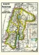
Historische Karte von PALÄSTINA 1869 (Plano)
Nachdruck 2014, Außergewöhnliche farbige Karte, Altkol. Lithographie nach und bei F.v. Rappard, Berlin, dat. Blattgröße (B x H) 70 x 100 cm, Bedrucktes Blatt (B x H) 67 x 91 cm. [Die Karte wird gerollt - in einer stabilen Papphülse - geliefert bis 72 cm lang, 250 g] Farbliche Markierungen auf der Karte: 1. Grenze von PALÄSTINA, 2. Grenzen der ...